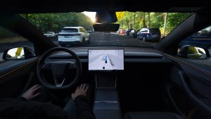
Tesla’s FSD visualizations are admittedly one of the coolest parts of owning a Tesla. Seeing vehicles all around you on the screen, and watching the car make decisions can be mesmerizing.
However, have you ever wondered exactly how the car generates the visualizations? Is it real-time, or does it rely on map data that is downloaded separately from the vehicle’s firmware?
Map Data
Tesla distributes map data to vehicles worldwide separately from its vehicle firmware versions. This means that the map data updates can have a different tempo than the firmware updates. For instance, some cars on 2024.8.9 (an FSD V11 version from ~3mo ago), as well as cars on 2024.14.7 (an FSD V12 version from just a few days ago) just started receiving the NA-2024.8-14924 map update last week. These updates ensure that vehicles can get the most current information about road layouts, traffic patterns, and other critical driving data.
While FSD can usually work with different map versions, how much does FSD and the in-car visualizations rely on the predefined map data? It obviously uses it for some things such as speed limit, but does it use it more than that? Thanks to user, ArthurFromX on X, we now have a better idea of how much relies on map data.
FSD Visualizations
Tesla’s FSD visualizations rely on a combination of pre-mapped data and real-time information gathered by the cameras. This approach provides both background context (pre-mapped data), as well as real-time context via computer vision.
It all comes together to provide an accurate representation of what the car sees around it, taking into account the width, height, and length of nearby vehicles, curbs, and other objects, such as garbage bins or traffic cones.
A post on X highlighted that FSD visualizations might be more impacted by background data than initially thought. The post mentioned that construction to a local roundabout rendered the visualizations inaccurate, although the car was correctly navigating the lane and making its exit.
This suggests that while real-time data is crucial, the accuracy of pre-mapped data still plays a significant role in the overall effectiveness of FSD visualizations, and perhaps a lesser role in the actual decision-making process of FSD.
FSD Navigation
Of course, these visualizations impact more than just what you see on screen. The mapping data and real-time data provide information on how the vehicle plans its path, and how it makes driving decisions, such as moving into right, or left-turn lanes as required.
Mapping data most likely provides background information, enabling the onboard hardware to process and work on driving the vehicle with an initial idea of where it is and what the road looks like.
In short, map data plays a backseat role to the actual driving of FSD, but does play a bigger role in route decision, as well as providing context and predictions to what the vehicle sees. It seems at the moment that visualizations are based on a combination of map data and camera data the vehicle gathers.
For a complete list of FSD visualizations supported, check out our FSD visualizations page.
Follow Us on Google
Add Not a Tesla App as a preferred source on Google to see more of our stories in Top Stories.
Add to Preferred SourcesOrdering a New Tesla?
Get FSD free for 3 months by using our referral code.